~~
Book of Mormon Lands ~~
Where Are They?
Smithsonian Institution Statement Regarding the Book of Mormon
Some Latter-day Saints, in their zeal to give tangible authenticity to the Book of Mormon, have told prospective converts that the Smithsonian Institution has used the Book of Mormon to verify sites in the New World. In response to numerous requests on this subject, the Smithsonian has issued the following paper detailing their position on the matter.
Information from the National Museum of Natural History Smithsonian Institution, Washington, D.C. 20560
Statement Regarding the Book of Mormon
1. The Smithsonian Institution has never used the Book of Mormon in any way as a scientific guide. Smithsonian archaeologists see no direct connection between the archaeology of the New World and the subject matter of the book.
2. The physical type of the American Indian is basically Mongoloid, being most closely related to that of the peoples of eastern, central, and northeastern Asia. Archaeological evidence indicates that the ancestors of the present Indians came into the New World -- probably over a land bridge known to have existed in the Bering Strait region during the last Ice Age -- in a continuing series of small migrations beginning from about 25,000 to 30,000 years ago.
3. Present evidence indicates that the first people to reach this continent from the East were the Norsemen who briefly visited the northeastern part of North America around A.D. 1000 and then settled in Greenland. There is nothing to show that they reached Mexico or Central America.
4. One of the main lines of evidence supporting the scientific finding that contacts with Old World civilizations, if indeed they occurred at all, were of very little significance for the development of American Indian civilizations, is the fact that none of the principal Old World domesticated food plants or animals (except the dog) occurred in the New World in pre-Columbian times. American Indians had no wheat, barley, oats, millet, rice, cattle, pigs, chickens, horses, donkeys, camels before 1492. (Camels and horses were in the Americas, along with the bison, mammoth, and mastodon, but all these animals became extinct around 10,000 B.C. at the time the early big game (sic) hunters spread across the Americas.)
5. Iron, steel, glass, and silk were not used in the New World before 1492 (except for occasional use of unsmelted meteoric iron). Native copper was worked used (sic) in various locations in pre-Columbian times, but true metallurgy was limited to southern Mexico and the Andean region, where its occurrence in late prehistoric times involved gold, silver, copper, and their alloys, but not iron.
6. There is a possibility that the spread of cultural traits across the Pacific to Mesoamerica and the northwestern coast of South America began several hundred years before the Christian era. However, any such inter-hemispheric contacts appear to have been the results of accidental voyages originating in eastern and southern Asia. It is by means certain that even such contacts occurred; certainly there were no contacts with the ancient Egyptians, Hebrews, or other peoples of Western Asia and the Near East.
7. No reputable Egyptologist or other specialist on Old World archaeology, and no expert on New World prehistory, has discovered or confirmed any relationship between archaeological remains in Mexico and archaeological remains in Egypt.
8. Reports of findings of ancient Egyptian, Hebrew, and other Old World writings in the New World in pre-Columbian contexts have frequently appeared in newspapers, magazines, and sensational books. None of these claims has stood up to examination by reputable scholars. No inscriptions using Old World forms of writing have been shown to have occurred in any part of the Americas before 1492 except for a few Norse rune stones which have been found in Greenland.
9. There are copies of the Book of Mormon in the library of the National Museum, of Natural History, Smithsonian Institution.
Geographical
Considerations
The Book of Mormon describes the world of its inhabitants as an
hourglass-shaped land mass made up of a "land southward"
surrounded by water except for a "narrow neck" of land
connecting it to a "land northward" (Alma 22:32). Determining
the location of these lands is the necessary first step before archaeology
can be employed to evaluate the Book of Mormon, as LDS scholars
acknowledge.
One might expect that determining the geographical setting of the Book of Mormon lands would be a fairly simple undertaking. Instead, the topic has become a matter of considerable controversy in which the theories of modern Mormon scholars are pitted against the traditional teaching of the LDS Church.
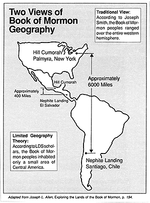
MAP 1
 The Traditional View
According to Joseph Smith and subsequent presidents and apostles of
the LDS Church, the geographical extent of Book of
Mormon lands included virtually all of North and South America. Joseph
Smith identified the coast of Chile as the place where Lehi's party
arrived in the New World, while he located the Hill Cumorah, site of the
epic Nephite-Lamanite battle to extinction, some 6000
miles north in Palmyra, New York. Thus, North and South America were
understood to constitute the two bulges of the hourglass, connected by the
"narrow neck" of Central America.
Joseph Smith also taught that the American Indians were the descendants of the Lamanites. The History of the Church records an incident from June 1834 in which he identified, by divine guidance, a skeleton found in an Indian burial mound in Illinois as that of the Lamanite warrior Zelph:
. . the visions of the past being opened to my understanding by the Spirit of the Almighty, I discovered the person whose skeleton was before us was a white Lamanite, a large, thick-set man, and a man of God. His name was Zelph . . . who was known from the Hill Cumorah, or eastern sea to the Rocky mountains.
The LDS Church continues to teach that Native Americans are the direct descendents of Book of Mormon peoples. For example, the "Introduction" in current editions of the Book of Mormon (since 1981), describes the Lamanites as, "the principal ancestors of the American Indians."
Why LDS Scholars Object
Despite the teaching of the Church's spiritual leaders, unquestioned
for a hundred years, a number of Mormon scholars have concluded that the
traditional view of Book of Mormon geography is unrealistic. Their
conclusions are based on a number of major problems that arise when one
attempts to apply Book of Mormon descriptions of travel times and
population growth to the vast territories of North and South America. For
instance, while the Book of Mormon makes it clear that the rival Nephite
and Lamanite civilizations were centered near the "narrow neck"
of land (understood to be somewhere in Central America), it says that they
agreed to meet for their epic final battle at the "hill Cumorah"
(Mormon 6:1-6). Joseph Smith and Mormon tradition locate this site several
thousand miles distant in New York state. It is difficult to find a
reasonable explanation for why the armies would travel this immense
distance to do battle.
Another significant problem for traditional Book of Mormon geography involves the premise that the native populations of the vast North and South American continents are the descendents of two tiny groups of transoceanic Semitic immigrants (the Jaredites, who arrived in the New World between 3000 - 2000 B.C. but later battled themselves to extinction, and the Nephites and Mulekites, who arrived beginning about 600 B.C.). Archaeological evidence shows conclusively that the western hemisphere was populated at least as far back as 10,000 B.C. by east Asian peoples who migrated across the Bering Strait. It is these Mongolian peoples who are the ancestors of the American Indians, according to the Smithsonian Institution:
The American Indians are physically Mongoloids and thus must have originated in eastern Asia. The differences in appearance of the various New World tribes in recent times are due to (1) the initial variability of their Asian ancestors; (2) adaptations over several millennia to varied New World environments; and (3) different degrees of interbreeding in post-Columbian times with people of European and African origins."
There is no solid evidence for immigration via other routes involving long sea voyages (prior to the Norse arrivals from Greenland and Newfoundland about A.D. 1000), as proposed by the Book of Mormon, and if such voyages did occur, they were not significant for the origins and composition of New World populations.
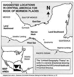
MAP 2
 The Limited Geography Theory
In order to remove these inherent improbabilities and protect the
credibility of the Book of Mormon as authentic history, a number of LDS
scholars have proposed a new approach to Book of Mormon geography called
the "limited geography theory." The most influencial proponent
of this view is Prof. John L. Sorenson of Brigham Young
University. Sorenson restricts the Book of Mormon setting to an
approximately 400-mile-long section of Central America, with the Isthmus
of Tehuantepec in southern Mexico corresponding to the "narrow
neck" of the hourglass-shaped land mass described above.
While the limited geography theory appears to resolve some of the flaws of traditional Book of Mormon geography, it creates other problems that are equally serious. It conflicts with details in the Book of Mormon, contradicts the teaching of a long line of LDS presidents and apostles, and in the end cannot produce a single piece of archaeological evidence that can be identified as Nephite or Jaredite (a fact which BYU professors such as Hugh Nibley, Bruce W. Warren, and David J. Johnson all acknowledge).
Two Cumorahs?
One area of major contradiction between the limited geography theory
and the Book of Mormon concerns the identity and location of the hill
Cumorah. Sorenson locates Cumorah in Central America, at a site only 90
miles from the "narrow neck". While this removes an unrealistic
requirement of the traditional view, which has the two
armies marching thousands of miles north to do battle at what is now
Palmyra, New York, it conflicts with the Book of Mormon description of
Cumorah as "an exceeding great distance" from the narrow neck
into the "land northward" (Helaman 3:3,4). If the Isthmus of
Tehuantepec — Sorenson's "narrow neck" of land — at 120
miles across is "narrow," how can the 90 miles from the
"narrow neck" to Sorenson's Cumorah fit the Book of Mormon
description of "an exceeding great distance"?
The limited geography theory also seems to be at odds with the Book of Mormon by requiring two Cumorahs. This is necessary since it locates the final Nephite-Lamanite battle at a Cumorah in Central America, whereas Joseph Smith retrieved the Book of Mormon plates from the traditional hill Cumorah in New York State. This also leaves Moroni with the task of single-handedly transporting the hefty Book of Mormon plates (not to mention the entire Nephite library) over two thousand miles to the New York Cumorah.
Directional Skewing
Another major discrepancy of the limited geography theory is the 45
degree directional skewing that results when the geographic features of
the Book of Mormon are superimposed onto the proposed Central American
site. MAP 2 illustrates the problem. It shows that the Book of
Mormon's "land northward" and "land southward" are
actually oriented along a northwest-southeast line. This places the
"east sea" and "west sea" almost directly north and
south of these proposed Book of Mormon lands. It is clear from the Bible
that the ancient Israelites used the rising sun as the basis for
directional orientation (e.g., Exodus 27:13; 38:13; Numbers 2:3; Ezekiel
8:16). Therefore, one must ask, "Would Hebrew immigrants arriving at
the proposed Central American site and using the sun as their directional
reference, have arrived at the severely skewed directional orientation
suggested by Sorenson?"
Still another conflict is the absence of the "sea north" and the "sea south" (Helaman 3:8). In the traditional view, these descriptions correspond to the Atlantic Ocean below the tip of the South America (Cape Horn), and the Arctic Ocean north of North America, respectively. Editions of the Book of Mormon from 1888 to 1921 included a note to this effect at Helaman 3:8-9. Because of these conflicts with Mormon tradition and Book of Mormon internal evidence, the limited geography theory has been repeatedly condemned by LDS leaders, including Joseph Fielding Smith, Jr. (10th President), Harold B. Lee (11th President), and Bruce R. McConkie. In 1978 the Church News labeled it "harmful" and a "challenge" to the "words of the prophets concerning the place where Moroni buried the records."
Book of Mormon geography raises a theological dilemma: on the one hand, the traditional view produces a number of improbabilities that undermine the historical credibility of the Book of Mormon; on the other hand, the limited geography approach rejects the clear pronouncements of Joseph Smith and subsequent presidents and apostles, and conflicts with Book of Mormon teaching on a number of important points.
An LDS Archaeologist's
Conclusion
As was noted earlier, the Bible and the Book of Mormon are alike in
presenting themselves as records of ancient history. However, whereas the
authenticity of the Bible is widely accepted even by secular scholars (see
article titled "Does Archaeology Support the Bible?"), no
non-LDS archaeologist accepts the Book of Mormon as
authentic history, and now even many LDS scholars no longer support
its historicity. Why do archaeologist take such a dim view of the Book of
Mormon?
One of the best answers to this question was offered by former Brigham Young University anthropology professor, Dr. Raymond T. Matheny at an August 25, 1984 Sunstone conference in Salt Lake City. After working in the area of Mesoamerican archaeology for twenty-two years, Prof. Matheny reported his conclusion that the scientific evidence simply does not support the existence of the peoples and events chronicled in the Book of Mormon, be it in Central America or anywhere else in the western hemisphere.
Dr. Matheny described the Book of Mormon as filled with anachronisms — things that are out of place historically and culturally. It introduces Old World cultural achievements into the pre-Columbian Americas, though the archaeological evidence shows no such levels of culture were attained during this period. Defenders of the historicity of the Book of Mormon are left with only scattered bits of evidence which they interpret apart from accepted scientific standards.
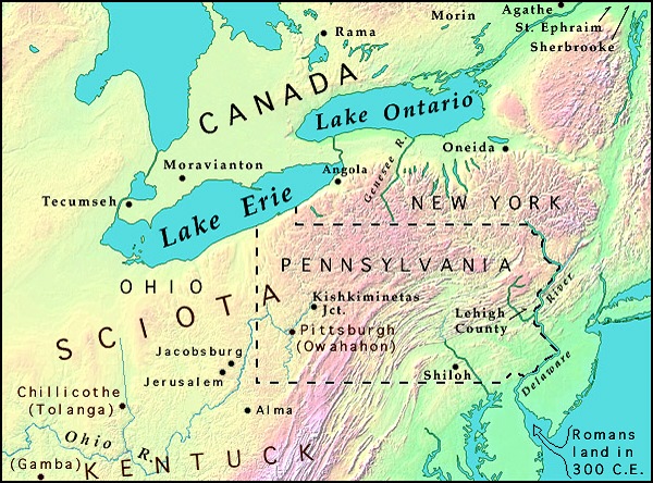
Actual places in North Eastern America, this is the picture from Spaulding's Manuscript story with place names and its setting in the great lakes area.

©1992 by Vernal Holley - limited web-reproduction rights
granted
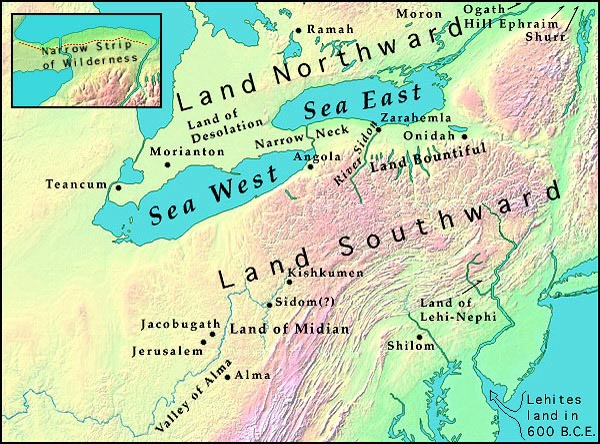
This second picture is the Book of
Mormon lands by the description given in the BoM, the narrow neck was a
day and a half walk the distance between the lakes is about 37miles.
Notice the names how nearly identical they are. Geography as proposed by
Vernal Holley (1983). Z = proposed city of Zarahemla site. Bright blue line is
the model's "River Sidon." Names in red represent towns not in
existence at the time of the Book of Mormon's publication. Note that the maps
available at Mazeministries contain the following errors: 1) Jerusalem and
Jacobsburg are too far apart; 2) Alma is too far to the east; 3) Mount Ephrim
should be north-east, not north-west of Sherbrooke.

©1992 by Vernal Holley - limited web-reproduction rights granted
The Book of Mormon is false and this shows it for what it is.